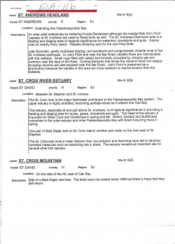
St. Andrews Headland
Type
Publication
Authors
Category
SCIWC Library
[ Browse Items ]
Pages
6
Subject
Environmentally Significant Areas in the St. Croix River Area
Tags
Description
This document is a review of Environmentally Significant Areas found in the St. Croix River Region of New Brunswick.
Each site has the following descriptors:
- Name
- Parish
- County
- Region
- Site ID
- Location
- Description
The sites are as follows:
- St. Andrews Headland
- St. Croix River Estuary
- St. Croix Mountain
- Dennis Stream
- Kendricks Lake
- Spragues Falls
- Waweig River
- Oak Bay / Spoon Island
- Highway 1, Exit 14 to St. Andrews
- Twin Lakes
- Grand Falls, St. Croix River
- Mohannes Stream
- King Brook Lake
- Clark Point
- Ballie Settlement White Cedar Stand
- Canoose Stream & Mouth
- Ballie Bog
- Loon Bay, St. Croix River
- Andersonville Bog
- Canoose Flowage
- St. Croix River/Grassy Islands
- Three Brooks Marsh/Upper Canoose
- Spednic Lake/Diggity Stream
- Hinckly Point
- East Grand Lake
- Grassy Lake
- Skiff Lake
Number of Copies
1


, Algonquin Signature Golf Course St. Andrews, Charlotte County, NB")