| |
Title |
Authors/Editors |
Publisher |
Type |
Copies |
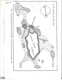 |
Map of Dochet Island with its surrounding ledges. From a survey by the author in September, 1902.
|
|
|
Other |
1 |
 |
St. Stephen3
|
|
|
Other |
1 |
|
|
|
|
|
|
1 |
 |
Wetland Trends for Selected Areas of the Cobscook Bay/St. Croix River Estuary of the Gulf of Maine (1975/77 to 1983-85)
|
|
|
Publications |
1 |
|
|
|
|
|
|
1 |
 |
Intl boundary markers & boundary location - St. Croix system
|
|
|
Other |
1 |
 |
Ecosystem Management in the United States: An Assessment of Current Experience
|
|
|
Publications |
1 |
|
|
|
|
|
|
1 |
 |
Forest Development Survey/Inventaire de L'etat du developpement des ressources forestieres93
|
|
|
Other |
1 |
 |
Historic Documents Related to the Anadromous Fisheries of the St. Croix River, Maine and Canada.
|
|
|
References |
1 |