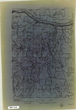
Topographic map of areas surrounding Canterbury, NB
Type
Reference
Authors
Category
Maps
[ Browse Items ]
Pages
1
Subject
Topographic
Tags
Description
Scale: 1:50,000
Dimensions: 30" x 21"
Location: Canterbury, York County, New Brunswick
Legend: Yes
Paper Type: Vellum
Description: Topographic map of areas surrounding Canterbury showing elevation changes (including contour lines), roads and highways- revisions outline compartments with unknown writing
Dimensions: 30" x 21"
Location: Canterbury, York County, New Brunswick
Legend: Yes
Paper Type: Vellum
Description: Topographic map of areas surrounding Canterbury showing elevation changes (including contour lines), roads and highways- revisions outline compartments with unknown writing
Number of Copies
1


